Thank goodness for comforts

My feet were so sore I felt like crawling, but mind over matter is the way forward and so, at the Mutitjulu/Kuniya carpark, I climbed onto the bus without a grimace but with a sigh of pleasure.  We shuttled back to the Ayers Rock Resort. I resolved to get off at the first hotel, have one or more well-deserved sparkling wines, and suss it out as a potential place for dinner one evening.

I staggered off the bus at the Sails in the Desert Hotel, the most expensive of the three hotels in this little tourist town.  I made it through an airy foyer with glass cases containing beautiful objects (none of which I had the energy to look at, regrettably) and collapsed into a comfortable chair in a light atrium. A waitress, travelling the world from France, kept me supplied with drinks while I logged into the WiFi and checked myself back into the electronic world. Apart from the fact I never wanted to stand on my feet again, I was chuffed. So profoundly happy.  So excited about the things I had seen and experienced during the day.

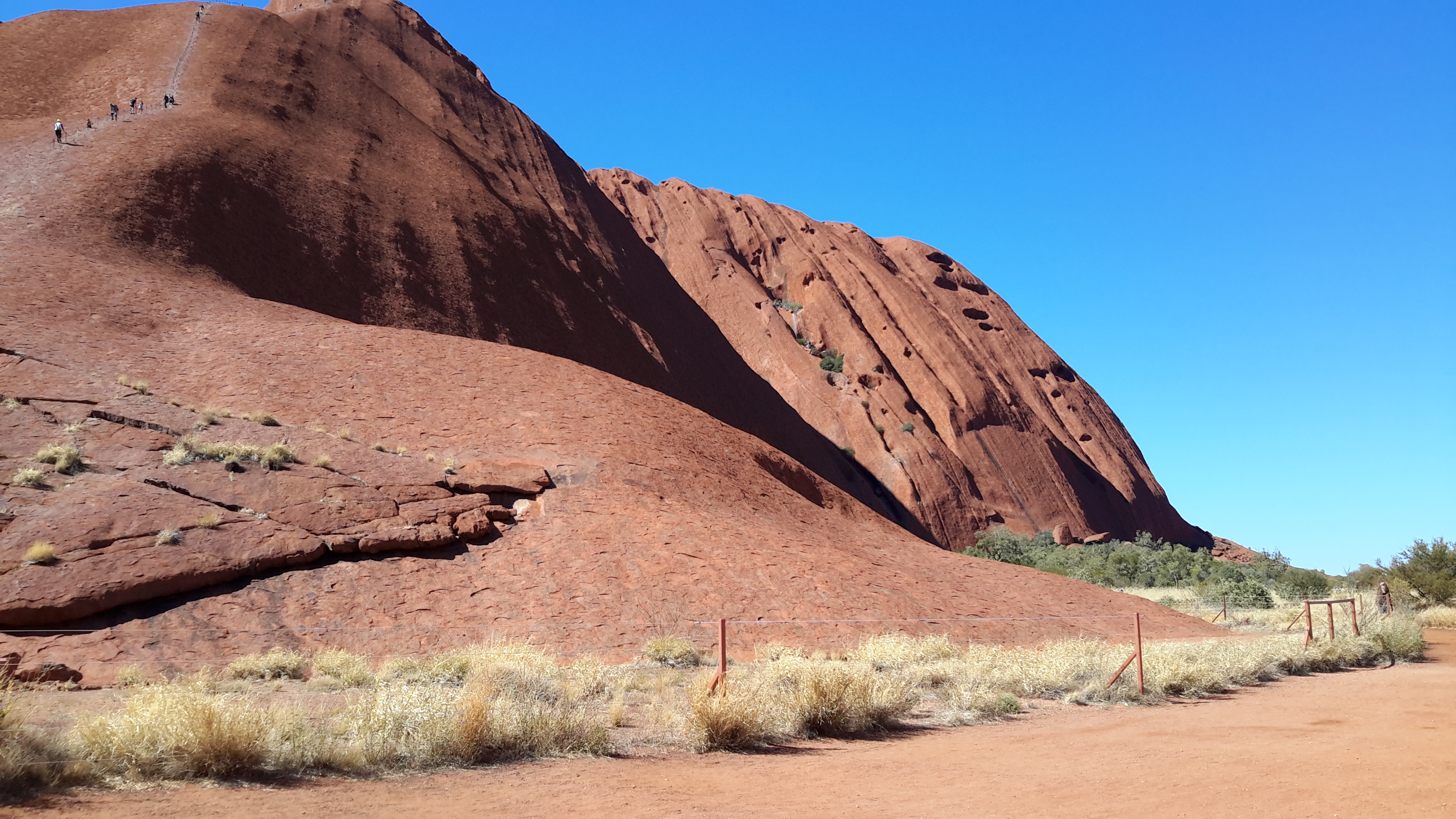
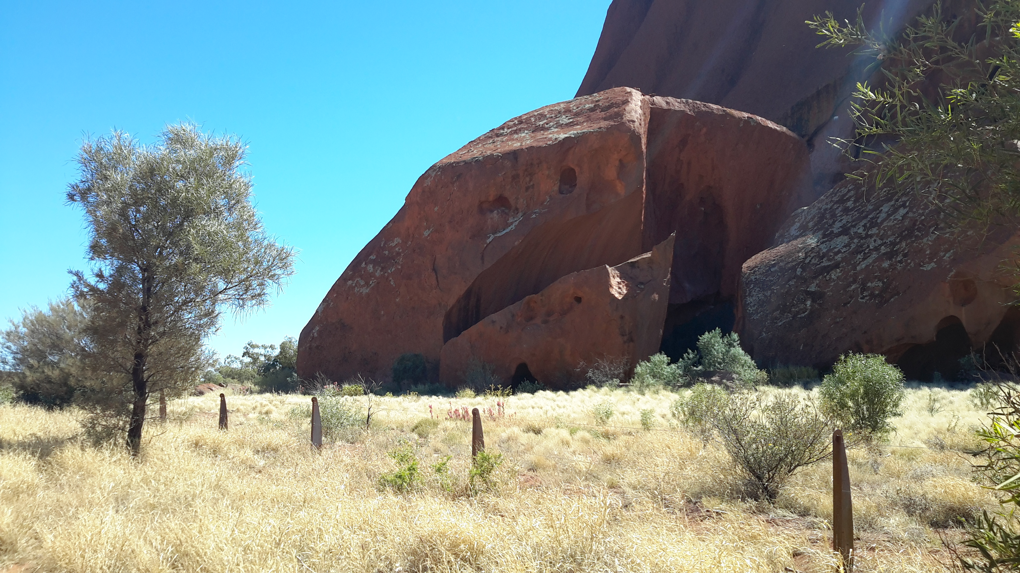
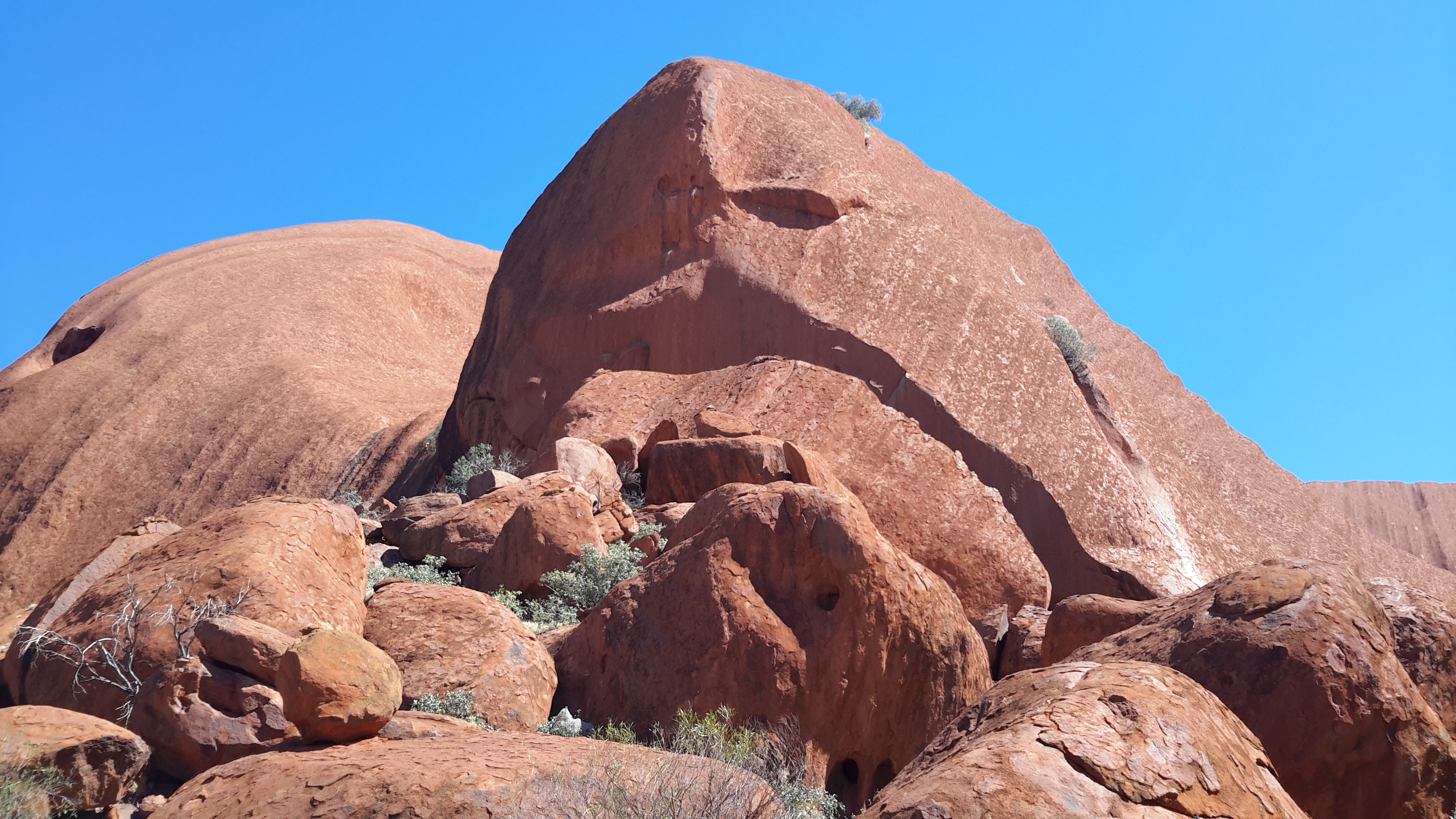
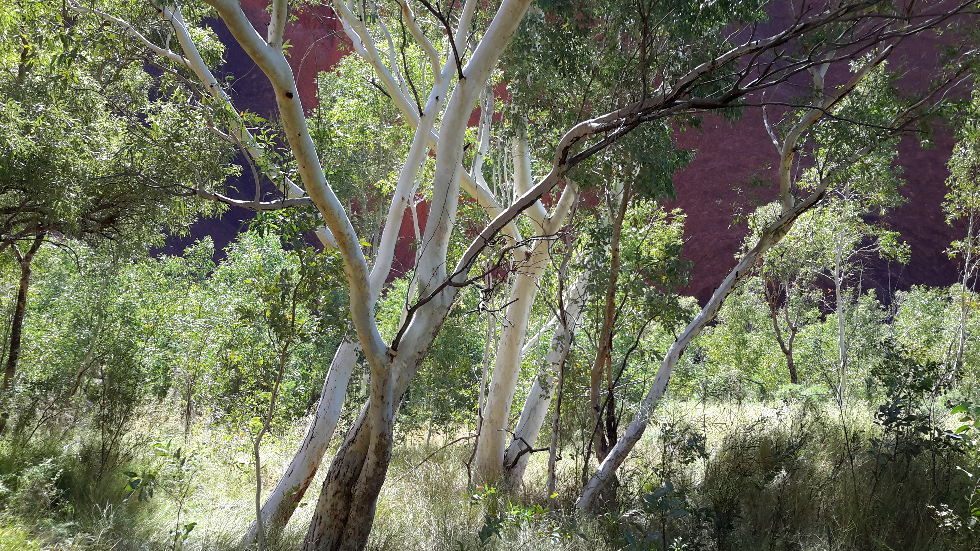
I took a much larger volume of photos than appear in this blog, and there were people I met and other situations which have not made it into the blog (if I included everything, then it could be Christmas next year before this series of blog posts are complete). It is sufficient to say my walk around Uluru was a remarkably rich experience mostly because of the landscape and the way the changing light affected it, and for its associated aboriginal histories.

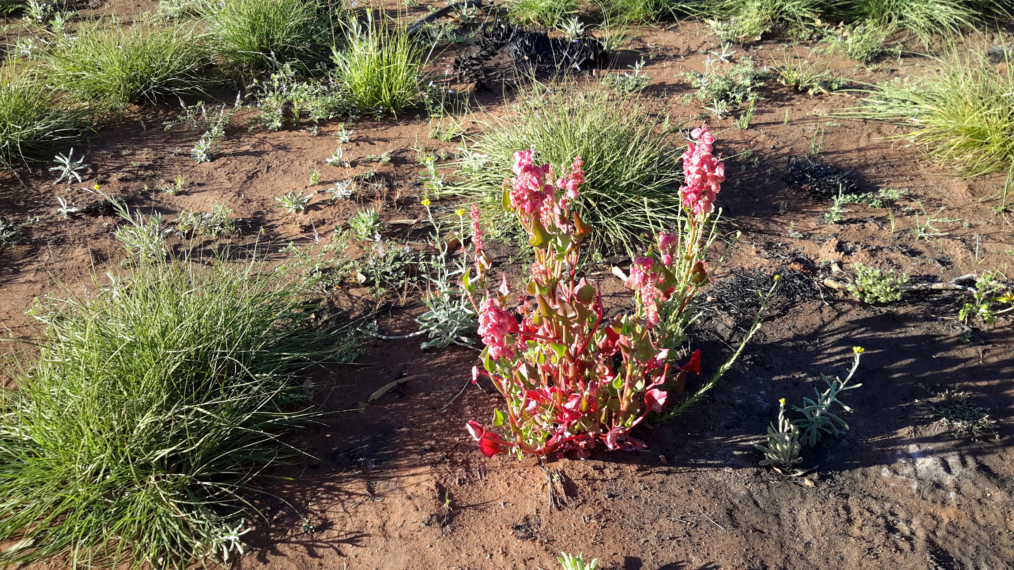
As I sat in the hotel I could see that I carried the dust as evidence of the walk – and even though I travelled back to Hobart in these boots that wonderful desert soil stayed attached. The photos show my greenish coloured leather boots as a shade of brown but it was red dust that coloured them.  Images in earlier blogposts show the red soil –I will add another below to remind you. IMG_0537

IMG_0539.JPG

20170831_091452.jpg  Before leaving the Sails in the Desert Hotel I visited the restaurant and realised Betty and I could expect an excellent meal. However while we planned to eat there one evening, the range of eating options across the Ayers Rock Resort township meant we were attracted to other places and we never made it.

Once the bus shuttled me back to the Outback Pioneer Hotel,  Betty and I prepared for dinner at our Hotel’s restaurant, the Bough Restaurant.  On offer – ‘For dinner, share in the spirit of outback Australia and enjoy a roast of the day served alongside a delicious buffet. Buffet selections offer international flavours that include vegetarian options, with a great selection of desserts to complete your meal.’ Unfortunately, dinner requires guests to be locked into a one-price deal so if you only planned to have a soup for example, this wasn’t possible unless you paid the full price.  At that stage of our experience in the Ayers Rock Resort township, the fact that a hospitality training school (the National Indigenous Training Academy)for indigenous peoples from all over Australia was stationed in the complex and their students had work experience in various venues across town, was not registering with us.  If we had known then we would have been more accommodating when we found offering a tip wasn’t straightforward, and when the bill for our evening meal was entered onto our room account incorrectly – all of which was solved later.

With the achievement of having walked around Uluru in mind, and fascinated by all of Betty’s local discoveries during the day, the excellent meal made me drowsy quickly.  Our first full day in this region was over. Bed beckoned and I was soon unconscious.

Taking the walk around Uluru – from Mala to Mutitjulu

This photo, from above Uluru, gives clear indications of the road and other features; photo courtesy of Andrew Bertuleit with my identifying names overlaid.  The viewpoint is from the northwest of the rock looking south eastwards.By Andrew Bertuleit with notes

The track heading south from Mala to the Mutitjulu waterhole and the Kuniya carpark, on the western side of Uluru, is the Lungkata Walk (Lungkata is the blue –tongued lizard man).

Uluru walks

My feet were so sore that I contemplated catching the Hop On Hop Off bus from the Mala carpark back to my hotel and returning another day to complete the last short section on the Lungkata Walk.  But I stuck to my plan because I knew the next bus to the Mutitjulu/Kuniya carpark was an hour and a half away and the walk should not take me less an hour even at my slowest.  I plodded off, taking last looks at the people climbing on Uluru.  Loving the very dramatic rock shapes.     20170831_105534

20170831_105538

20170831_105708And then I was back to admiring the rock surface.20170831_10573820170831_105843 20170831_105846

20170831_110026Ahead of me the rock shapes, caves and deeply indented gorges were similar to those seen on the first two legs of the walk.  20170831_110158 20170831_110542

20170831_110906

20170831_111206  With the heating sun I was pleased that this track, in places, had more trees to provide protection.  20170831_11155620170831_111740

20170831_112243

20170831_112912Some distance along the way, another sacred site for aboriginal men’s ceremonies was marked.20170831_113748Some of the track was exposed and unsheltered and I felt the heat keenly. 20170831_113951

20170831_114227I should note that the walk around Uluru was incredibly easy for people with able bodies who don’t get sore feet.  The flat and smooth track was so good that I felt people in wheelchairs could race around Uluru. Nothing to trip on except your own feet if you are that way inclined. Different people had ideas of how long a typical person would take to get around the rock and the times varied from 1.5 hours to 3 hours. The walk took me 3.25 hours not counting my rest at Mala – but including hundreds of photo stops. The walk seemed a smidgin easier when in the shade again and with the greenness of trees around.  20170831_114745

20170831_114907  I was relieved when it was clear that my walk was ending and that the Mutitjulu waterhole was close by.  20170831_115250

20170831_115317One sign indicated the presence of native figs outside a cave where families of aboriginals had rested. One large tree/bush was covered in small native figs; those coloured red indicated they were ripe.  Ochre paintings adorned the cave ceiling and walls.  Other signage provided information about the family cave, with its entrances on two sides. These caves are still used by Anangu people.20170831_115411

20170831_115443

20170831_115558

20170831_120041

20170831_120100

20170831_120044

20170831_120056From the cave, the track continued to the waterhole and its viewing platform through an open woodland with grasses. 20170831_120304

20170831_121211

20170831_120336

20170831_120644

20170831_120345

20170831_120513Only a small amount of water pooled at the bottom of a steep hill.  The last rain was 8 months ago. This waterhole is the home of Wanampi, an ancestral watersnake.  20170831_120554

20170831_120601

20170831_120616The story of a python woman and poisonous snake man is the basis for this important location in aboriginal history;  details on the sign below.20170831_121028Then it was time to stumble back to the carpark and wait for the Hop On Hop Off bus.  The beautifully constructed rustic furniture was a boon for sore feet.  Under cover, I sat on another wooden ‘couch’ and looked out over the landscape at the southern side of Uluru now in shade, with the sun almost overhead.  I had the chance to talk with other visitors, and to begin to get my mind back into being social again. 20170831_121022

20170831_121545But overall I mused about the nature of Uluru with all its indentations and ‘scales’.  After seeing acres of promotional tourism photos, none have ever displayed the complexity of this rock.  I hope you, like me, have been astonished.  In addition I hope that, by seeing the differences in the rock and environment in the photos I have presented for the Kuniya, Base and Lungkata Walks that circle the rock, you have a new appreciation of Uluru’s size and power.

Taking the walk around Uluru – from Mutitjulu/Kuniya to Kuniya Piti

The Hop On Hop Off bus driver advised me to start my 10-11 km walk around the base of Uluru from the Mala carpark but I wanted to get going as soon as possible.  I also wanted to test myself on a shorter section to see whether I was physically able to complete the walk. The longest section is between Mala and Kuniya Piti and so I wanted to try something simpler first. As it turned out, Mutitjulu/Kuniya was the best starting place early in the morning.  The Mutitjulu start is about half way along the southern long side of the rock so, as I walked, I was facing directly into the sun, then I turned the corner for a long walk on a shorter eastern side of Uluru with the sun on my right side.  At the turn towards the Mala carpark, located about 2/3rds of the way along the northern side of the rock, I had the sun behind me.  If I have waited and got off the shuttle bus at Mala then for most of the walk the sun would have been in my eyes. I tried to explain this to the bus driver later (same one who had previously advised me) but he didn’t seem to understand.

The track heading east from Kuniya carpark near the Mutitjulu Waterhole to the Kuniya Piti carpark is titled the Kuniya Walk.

Uluru walks.JPG

20170831_073223.jpgInitially it was very cold even though I was rugged up with beanie and warm jacket.  As I walked from the carpark to start on the circular track, the sun struck the rock hard creating strong contrasts (while some edges remained totally in shadow).  This was the start of an hour or so of squinting to minimise the glare.20170831_073411.jpg

20170831_073241.jpg

20170831_073419.jpg

20170831_073746.jpgThen I was walking on the circular track heading east. Desert flowers (it was springtime) flourished everywhere.  The world was alive!  I felt alive!     20170831_073714.jpg

20170831_074517.jpg

20170831_074706.jpg

20170831_075733.jpg

20170831_075136.jpg

20170831_080200.jpg

20170831_080844.jpg

20170831_082030.jpgI marvelled at the surface of the rock. Worn seemingly smooth. Sculptured by the weather over millions of years. Then, up close I could see the surface was scaly. 20170831_073928.jpg

20170831_074037.jpg

20170831_074053.jpg  One lower section presented as a worn unbroken wave. At every turn the rock presented dramatic vistas.  My heart wanted to burst with the joy of the privilege of being here, the gratitude that I could walk, and the pleasure of seeing new ways to understand the look of Uluru.     20170831_074222.jpg

20170831_074428.jpg

20170831_074434.jpg

20170831_075023.jpg

20170831_075920.jpg

20170831_080232.jpg

20170831_080310.jpg

20170831_080653.jpg

20170831_081425.jpgI watched birds swoop in and out of some of the higher caves; the small size of the birds in comparison to the size of the rock means they are not visible on my closer cave specific photos.

As I neared the Kuniya Piti carpark the rock sloped more gradually towards the ground, and gave me new opportunities to closely inspect the ‘scale’ of this otherwise comparatively smooth rock.      20170831_081835.jpg

20170831_081910.jpg

20170831_081915.jpg

20170831_082145.jpgEventually I reached the sensitive area at Kuniya Piti where men’s ceremonies would be held in the distance; the track made a very wide berth around this eastern part of the rock.20170831_082412.jpg

20170831_082547.jpgHave you been amazed by the irregular rocky structure as shown in this small selection of photos (I took over a 100 photos on this short section alone)?  Is this type of imagery all new to you?

From the north to the middle

This blogsite was always going to offer a changing feast.

The last set of blog posts introduced you to an aspect of Far North Queensland;  some of the savannah country (with a smattering of tropical rainforest thrown in for good measure) out west of Cairns.

This new set of blog posts will take you into the heart of Australia; to Alice Springs, to the east and west MacDonnell Ranges and then southwards to Uluru (formerly known as Ayers Rock) and Kata Tjuta (formerly known as The Olgas) – all within Australia’s Northern Territory.

A series of maps (courtesy of Google Maps) will help you to locate the places I visited. The red indicator in the map below pinpoints the town of Alice Springs which was the starting point of my exploration and personal discoveries.

Australia.JPG

The Northern Territory represents  millions of hectares of land.  Its capital Darwin is almost 1500 kilometres north of Alice Springs.

Alice Springs.JPG

The following map shows both Alice Springs and Yulara, the base point for visiting Uluru and Kata Tjuta.  These two towns are approximately 450 kilometres apart.

Alice and Yulara and Mititjulu.JPG

Initially I planned to investigate the east and the west MacDonnell Ranges to the extent that time and resources allowed.  I have circled a topographical view of those ranges stretching in both directions from Alice Springs for a total length of around 500 kilometres.  Looking at this landscape using Google maps, before departure, amazed me because of the dramatic shapes of the geological structures.

McDonnells circled.jpg

The day after arrival in Alice Springs I was on the road eastwards. The topographical map below shows an ancient landscape in the east MacDonnell ranges.  The rocks around Chillagoe (seen in earlier posts on this blogsite) are 400 million years old and these are around 800 million years old.

East McDonnells.JPG

A few days later, I entered the west MacDonnell Ranges.

West McDonnells.JPG

The second part of my central Australian trip involved travelling to the south west corner of the Northern Territory to see Uluru and Kata Tjuta. The cluster of rocks on the left is Kata Tjuta, and the township of Mutitjulu is slightly south east of Uluru on the lower right of the map below.

Kata Tjuta and Uluru and Yulara.JPG